
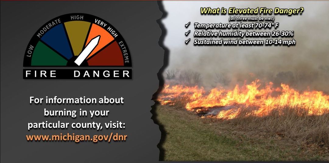
National Fire Danger Rating System
The National Fire Danger Rating System (NFDRS) is a system that allows fire managers to estimate today’s or tomorrow’s fire danger for a given area. It combines the effects of existing and expected states of selected fire danger factors into one or more qualitative or numeric indices that reflect an area’s fire protection needs. It links an organization’s readiness level (or pre-planned fire suppression actions) to the potential fire problems of the day. 5 different color-coded levels are used to help the public understand the fire potential.
Fire Danger Level: Low (Green)
When the fire danger is “low” it means that fuels do not ignite easily from small embers, but a more intense heat source, such as lightning, may start fires in duff or dry rotten wood. Fires in open, dry grasslands may burn easily a few hours after a rain, but most wood fires will spread slowly, creeping or smoldering. Control of fires is generally easy.
Fire Danger Level: Moderate (Blue)
When the fire danger is “moderate” it means that fires can start from most accidental causes, but the number of fire starts is usually pretty low. If a fire does start in an open, dry grassland, it will burn and spread quickly on windy days. Most wood fires will spread slowly to moderately. Average fire intensity will be moderate except in heavy concentrations of fuel, which may burn hot. Fires are still not likely to become serious and are often easy to control.
Fire Danger Level: High (Yellow)
When the fire danger is “high”, fires can start easily from most causes and small fuels (such as grasses and needles) will ignite readily. Unattended campfires and brush fires are likely to escape. Fires will spread easily, with some areas of high-intensity burning on slopes or concentrated fuels. Fires can become serious and difficult to control unless they are put out while they are still small.
Fire Danger Level: Very High (Orange)
When the fire danger is “very high”, fires will start easily from most causes. The fires will spread rapidly and have a quick increase in intensity, right after ignition. Small fires can quickly become large fires and exhibit extreme fire intensity, such as long-distance spotting and fire whirls. These fires can be difficult to control and will often become much larger and longer-lasting fires.
Fire Danger Level: Extreme (Red)
When the fire danger is “extreme”, fires of all types start quickly and burn intensely. All fires are potentially serious and can spread very quickly with intense burning. Small fires become big fires much faster than at the “very high” level. Spot fires are probable, with long-distance spotting likely. These fires are very difficult to fight and may become very dangerous and often last for several days.
Know before you Burn
Burn permits are issued based on local fire risk and weather conditions. The DNR issues burn permits online at Michigan.gov/BurnPermit if weather and fire danger conditions are favorable. Residents are encouraged to frequently check the website to see when it is safe to burn, when there are restrictions in place and it is unsafe to burn, and when restrictions are lifted.
When burn permits are not being issued, it means that there is no OPEN BURNING permitted. Open burning means the burning of unwanted materials such as paper, trees, brush, leaves, grass, and other debris not contained. Burn permits are required for open burning. Recreational campfires are not included in Open Burning permit regulations.
YOU CAN BE FINED FOR OPEN BURNING
Under Part 515 of Act 451 – The prevention and suppression of Forest Fires, Section 324.51512: Violation of Part or Rule; Penalty – Any person who violates this part or any rule promulgated under this part is guilty of a misdemeanor. Any person convicted of violating section 51510 is guilty of a felony and upon conviction shall be imprisoned for not more than 10 years or fined not more than $10,000.00, or both.
Newaygo County Community Wildfire Protection Plan
Newaygo County actively maintains a Community Wildfire Protection Plan. The purpose of this plan is to save lives, minimize damage, and enhance emergency response operations during a catastrophic wildland fire in Newaygo County. This plan identifies and prioritizes Wildland/Urban Interface areas within Newaygo County for hazardous fuels reduction treatments and recommends methods for achieving hazardous fuels reductions. In addition, this plan sets forth the emergency response organizational structure and management system under which Newaygo County will operate during a wildfire incident. It describes how different government and non-governmental entities will interact with each other to effectively disseminate out emergency alerts and information, conduct emergency evacuations, and shelter persons who would be impacted by a wildfire incident.
Within Newaygo County, seven Wildland Urban Interface (WUI) areas have been identified. Wildland Urban Interface areas are broadly defined as areas where homes are built near or among lands prone to wildfire. These lands include forests, grasslands, shrub lands, and other natural areas that have not been significantly modified by agriculture or human development. More specifically, Wildland Urban Interface areas are lands with a higher housing density, more than one housing unit per 40 acers, which are adjacent to natural areas or where wildlands dominate the landscape.
Utilizing townships as a geographical boundary for the Wildland Urban Interface Community allowed the local communities latitude in setting local priorities and activities related to fire risk reduction and buffer zones. These activities include; fire protection and preparedness, hazardous fuels reduction, restoration of healthy forests, fire prevention and ecosystem based planning. The following are identified Wildland Urban Interface Areas within Newaygo County:
- Big Prairie Township
- Brooks Township
- Croton Township
- Everett Township
- Lilley Township
- Merrill Township
- Wilcox Township
Through development and use of the Newaygo County Community Wildfire Protection Plan, the Emergency Services Department has been able to leverage over $582,000.00 in federal grant funds to reduce hazardous wildfire fuels in high risk neighborhoods adjacent to the Huron Manistee National Forest.
Lilley Township: Pickerel Woods Association Fuels Reduction Project, September 2018 ($100,650) July 2020 ($48,000)
The purpose of this project was to reduce hazardous fuels by removing a large concentration of Jack Pine along 15 Mile Road and Pickeral Woods Trail and creating a safe ingress and egress by removing restricting obstacles within 5 feet of either side of Pickeral Woods Trail. The area treated was approximately 238 acres impacting 20 residents on a one lane roadway. After the initial project, a second project was completed in 2020 by treating 9 parcels and approximately 10 acres on Old Ferris L. Funding was through the FY2015 Cooperative Forestry Assistance Act of 1978 Grant Funding and the U.S. Department of Agriculture Forest Service Secure Rural Schools and Community Self Determination Act of 2000 Title III.
For additional information on these types of projects please contact the Emergency Services Department.